
Make a donation
Gear up for your next adventure:
As an Amazon Associate, this site earns from qualifying purchases at no extra cost to you.
Rising Sun topographic map
Click on the map to display elevation.
Make a donation
Gear up for your next adventure:
As an Amazon Associate, this site earns from qualifying purchases at no extra cost to you.
About this map
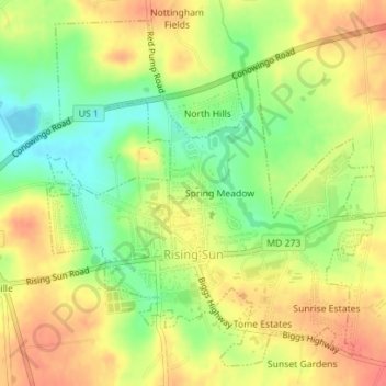
Name: Rising Sun topographic map, elevation, terrain.
Location: Rising Sun, Cecil County, Maryland, United States (39.68949 -76.08432 39.71433 -76.02988)
Average elevation: 390 ft
Minimum elevation: 240 ft
Maximum elevation: 509 ft
Cecil County trails, hiking, mountain biking, running and outdoor activities
Make a donation
Gear up for your next adventure:
As an Amazon Associate, this site earns from qualifying purchases at no extra cost to you.
Other topographic maps
Click on a map to view its topography, its elevation and its terrain.
Make a donation
Gear up for your next adventure:
As an Amazon Associate, this site earns from qualifying purchases at no extra cost to you.
Make a donation
Gear up for your next adventure:
As an Amazon Associate, this site earns from qualifying purchases at no extra cost to you.
Frenchtown
United States > Maryland > Cecil County > Perryville > Frenchtown
Average elevation: 115 ft