
Make a donation
Gear up for your next adventure:
As an Amazon Associate, this site earns from qualifying purchases at no extra cost to you.
Crestline topographic map
Click on the map to display elevation.
Make a donation
Gear up for your next adventure:
As an Amazon Associate, this site earns from qualifying purchases at no extra cost to you.
Crestline
Crestline was platted in 1852. It was once thought to be the highest point in Ohio and was named from its high elevation.
Make a donation
Gear up for your next adventure:
As an Amazon Associate, this site earns from qualifying purchases at no extra cost to you.
About this map
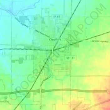
Name: Crestline topographic map, elevation, terrain.
Location: Crestline, Crawford County, Ohio, 44827, United States (40.75675 -82.78997 40.80278 -82.71808)
Average elevation: 1,165 ft
Minimum elevation: 1,112 ft
Maximum elevation: 1,260 ft
Crawford County trails, hiking, mountain biking, running and outdoor activities
Make a donation
Gear up for your next adventure:
As an Amazon Associate, this site earns from qualifying purchases at no extra cost to you.