
Cle Elum topographic map
Click on the map to display elevation.
Cle Elum
Cle Elum was originally inhabited by the Kittitas band of the Yakama tribe. The tribe fished salmon, steelhead, and trout from the Yakima River. The Salmon la Sac trails in the northern area of the region were created by the Kittitas people and were used as layovers for journeys into the higher altitudes of the Cascade Range. In 1855, after the arrival of Catholic missionaries, and the passing through of settlers and coal miners on their way to the Puget Sound, a treaty resulted in the Yakamas ceding most of their land for a reservation in the lower Yakima Valley and guaranteed access to fish, including what would later be incorporated as Cle Elum. By 1859, the Kittitas had been forced to relocate to the Yakama Indian Reservation.
About this map
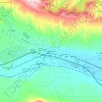
Name: Cle Elum topographic map, elevation, terrain.
Location: Cle Elum, Kittitas County, Washington, United States (47.18434 -121.01610 47.20680 -120.90000)
Average elevation: 2,283 ft
Minimum elevation: 1,841 ft
Maximum elevation: 3,471 ft
Kittitas County trails, hiking, mountain biking, running and outdoor activities
Other topographic maps
Click on a map to view its topography, its elevation and its terrain.
Cathedral Rock
United States > Washington > Kittitas County
Cathedral Rock is an intrusive andesite volcanic complex. The Alpine Lakes Wilderness features some of the most rugged topography in the Cascade Range with craggy peaks and ridges, deep glacial valleys, and granite walls spotted with over 700 mountain lakes. Geological events occurring many years ago created…
Average elevation: 5,075 ft
Hyak
United States > Washington > Kittitas County
Hyak is located two miles (3 km) east of the summit of Snoqulamie Pass at an elevation of 2,600 feet (790 m). It is 16 miles (26 km) northwest of Easton and is part of the Easton school district.
Average elevation: 2,976 ft
Cathedral Rock
United States > Washington > Kittitas County
Cathedral Rock is an intrusive andesite volcanic complex. The Alpine Lakes Wilderness features some of the most rugged topography in the Cascade Range with craggy peaks and ridges, deep glacial valleys, and granite walls spotted with over 700 mountain lakes. Geological events occurring many years ago created…
Average elevation: 5,075 ft