
Make a donation
Gear up for your next adventure:
As an Amazon Associate, this site earns from qualifying purchases at no extra cost to you.
Saspow topographic map
Click on the map to display elevation.
Make a donation
Gear up for your next adventure:
As an Amazon Associate, this site earns from qualifying purchases at no extra cost to you.
About this map
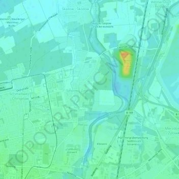
Name: Saspow topographic map, elevation, terrain.
Location: Saspow, Cottbus, Brandenburg, Deutschland (51.76913 14.34430 51.80598 14.37612)
Average elevation: 223 ft
Minimum elevation: 200 ft
Maximum elevation: 308 ft
Make a donation
Gear up for your next adventure:
As an Amazon Associate, this site earns from qualifying purchases at no extra cost to you.
Other topographic maps
Click on a map to view its topography, its elevation and its terrain.
Cottbus
Deutschland > Brandenburg > Cottbus
In der Weimarer Republik begegnete man der Wohnungsnot mit staatlichen Programmen. Aber nicht nur preisgünstiger Wohnraum wurde gebraucht, auch die Feuerwehr musste leistungsfähiger werden. Der Bau der neuen Feuerwache trug diesen Anforderungen im einfachen sachlichen Baustil der Moderne Rechnung. Seine…
Average elevation: 259 ft