
Make a donation
Gear up for your next adventure:
As an Amazon Associate, this site earns from qualifying purchases at no extra cost to you.
Wehrshausen topographic map
Click on the map to display elevation.
Make a donation
Gear up for your next adventure:
As an Amazon Associate, this site earns from qualifying purchases at no extra cost to you.
Wehrshausen
Wehrshausen liegt rund 3 km westlich der Kernstadt von Marburg am westlichen Hang des Marburger Rückens in waldreicher Umgebung. Unmittelbar östlich des Ortes verlief auf dem Höhenrücken die Weinstraße (Wagenstraße) als mittelalterliche Handelsstraße.
Make a donation
Gear up for your next adventure:
As an Amazon Associate, this site earns from qualifying purchases at no extra cost to you.
About this map
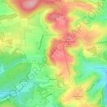
Name: Wehrshausen topographic map, elevation, terrain.
Average elevation: 922 ft
Minimum elevation: 673 ft
Maximum elevation: 1,188 ft
Make a donation
Gear up for your next adventure:
As an Amazon Associate, this site earns from qualifying purchases at no extra cost to you.
Other topographic maps
Click on a map to view its topography, its elevation and its terrain.
Dilschhausen
Deutschland > Hessen > Landkreis Marburg-Biedenkopf > Marburg > Dilschhausen
Average elevation: 988 ft