
Make a donation
Gear up for your next adventure:
As an Amazon Associate, this site earns from qualifying purchases at no extra cost to you.
Milford topographic map
Click on the map to display elevation.
Make a donation
Gear up for your next adventure:
As an Amazon Associate, this site earns from qualifying purchases at no extra cost to you.
About this map
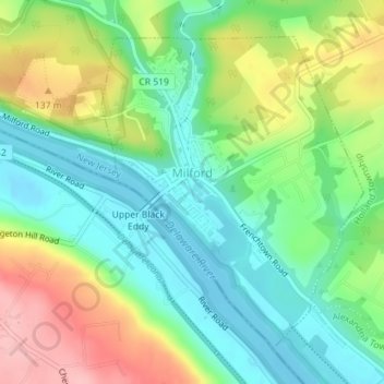
Name: Milford topographic map, elevation, terrain.
Location: Milford, Hunterdon County, New Jersey, United States (40.55633 -75.10300 40.57828 -75.07876)
Average elevation: 276 ft
Minimum elevation: 108 ft
Maximum elevation: 568 ft
Make a donation
Gear up for your next adventure:
As an Amazon Associate, this site earns from qualifying purchases at no extra cost to you.
Other topographic maps
Click on a map to view its topography, its elevation and its terrain.
Raven Rock
United States > New Jersey > Hunterdon County > Delaware Township
Average elevation: 285 ft
Centerville
United States > New Jersey > Hunterdon County > Readington Township
Average elevation: 161 ft
Make a donation
Gear up for your next adventure:
As an Amazon Associate, this site earns from qualifying purchases at no extra cost to you.
Ringoes
United States > New Jersey > Hunterdon County > East Amwell Township
Average elevation: 246 ft
Klinesville
United States > New Jersey > Hunterdon County > Raritan Township
Average elevation: 430 ft
Wertsville
United States > New Jersey > Hunterdon County > East Amwell Township
Average elevation: 236 ft
Make a donation
Gear up for your next adventure:
As an Amazon Associate, this site earns from qualifying purchases at no extra cost to you.
Ringoes
United States > New Jersey > Hunterdon County > East Amwell Township
Average elevation: 246 ft
Rileyville
United States > New Jersey > Hunterdon County > East Amwell Township
Average elevation: 410 ft
Quakertown
United States > New Jersey > Hunterdon County > Franklin Township
Average elevation: 571 ft
Make a donation
Gear up for your next adventure:
As an Amazon Associate, this site earns from qualifying purchases at no extra cost to you.
Whitehouse Station
United States > New Jersey > Hunterdon County > Readington Township
Average elevation: 200 ft
Make a donation
Gear up for your next adventure:
As an Amazon Associate, this site earns from qualifying purchases at no extra cost to you.
Pleasant Run
United States > New Jersey > Hunterdon County > Readington Township
Average elevation: 207 ft
Larisons Corners
United States > New Jersey > Hunterdon County > Larisons Corners
Average elevation: 217 ft
Make a donation
Gear up for your next adventure:
As an Amazon Associate, this site earns from qualifying purchases at no extra cost to you.
Make a donation
Gear up for your next adventure:
As an Amazon Associate, this site earns from qualifying purchases at no extra cost to you.