
Make a donation
Gear up for your next adventure:
As an Amazon Associate, this site earns from qualifying purchases at no extra cost to you.
Kaaksburg topographic map
Click on the map to display elevation.
Make a donation
Gear up for your next adventure:
As an Amazon Associate, this site earns from qualifying purchases at no extra cost to you.
Kaaksburg
Über ihre Entstehung und Funktion ist nicht viel bekannt. Der ovale Ringwall mit einem Durchmesser von 80 bzw. 100 m und einer Höhe von ca. 5 m wurde aus dunkler Erde aufgeworfen, während der Boden in der Umgebung sandig ist, weshalb angenommen wurde, dass das Material aus der im Südosten vorbeifließenden Bekau stammt. Zumindest nach Norden und Osten war der Ringwall zudem von einem Graben umgeben. Im Westen fließt zudem der in die Bekau mündende Mehlbeker Mühlenbach entlang.
Make a donation
Gear up for your next adventure:
As an Amazon Associate, this site earns from qualifying purchases at no extra cost to you.
About this map
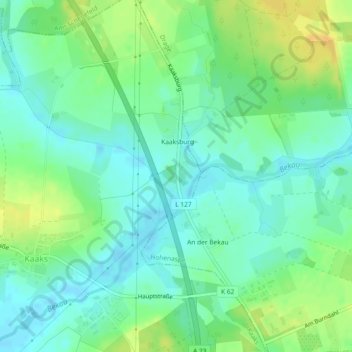
Name: Kaaksburg topographic map, elevation, terrain.
Average elevation: 36 ft
Minimum elevation: -3 ft
Maximum elevation: 92 ft
Make a donation
Gear up for your next adventure:
As an Amazon Associate, this site earns from qualifying purchases at no extra cost to you.