
Make a donation
Gear up for your next adventure:
As an Amazon Associate, this site earns from qualifying purchases at no extra cost to you.
Hiddesen topographic map
Click on the map to display elevation.
Make a donation
Gear up for your next adventure:
As an Amazon Associate, this site earns from qualifying purchases at no extra cost to you.
Hiddesen
Der niedrigste Punkt des Ortes liegt am östlichen Rand im Friedenstal mit 146 m ü. NHN, in der Ortsmitte beträgt die Höhe 187 m. Am Maiweg liegt der höchste bewohnte Teil des Ortes mit 227 m, der höchste Punkt auf Hiddeser Gemarkung ist jedoch der Bielstein mit 393 Metern. Hier steht der Sender Teutoburger Wald.
Make a donation
Gear up for your next adventure:
As an Amazon Associate, this site earns from qualifying purchases at no extra cost to you.
About this map
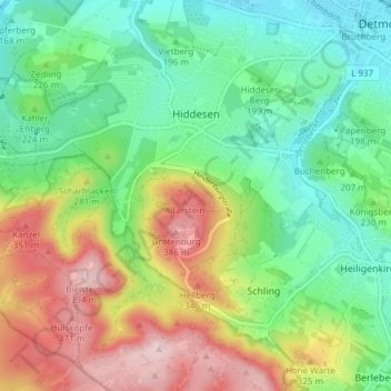
Name: Hiddesen topographic map, elevation, terrain.
Location: Hiddesen, Detmold, Kreis Lippe, Nordrhein-Westfalen, Deutschland (51.89540 8.79298 51.93606 8.86842)
Average elevation: 761 ft
Minimum elevation: 433 ft
Maximum elevation: 1,316 ft
Make a donation
Gear up for your next adventure:
As an Amazon Associate, this site earns from qualifying purchases at no extra cost to you.
Other topographic maps
Click on a map to view its topography, its elevation and its terrain.
Make a donation
Gear up for your next adventure:
As an Amazon Associate, this site earns from qualifying purchases at no extra cost to you.
Stemberg
Deutschland > Nordrhein-Westfalen > Kreis Lippe > Detmold > Berlebeck
Average elevation: 873 ft
Lippischer Meierhof
Deutschland > Nordrhein-Westfalen > Kreis Lippe > Detmold
Average elevation: 587 ft
Make a donation
Gear up for your next adventure:
As an Amazon Associate, this site earns from qualifying purchases at no extra cost to you.