
Make a donation
Gear up for your next adventure:
As an Amazon Associate, this site earns from qualifying purchases at no extra cost to you.
Neulautern topographic map
Click on the map to display elevation.
Make a donation
Gear up for your next adventure:
As an Amazon Associate, this site earns from qualifying purchases at no extra cost to you.
Neulautern
Das Gebiet der ehemaligen Gemeinde ist mit einer Fläche von 253 ha relativ klein und überwiegend mit Wald bedeckt, der die Höhen beiderseits des schmalen Wiesentals der Lauter bedeckt. Größere Nachbarorte sind Spiegelberg (Rems-Murr-Kreis) im Süden, Wüstenrot im Nordosten und der Beilsteiner Weiler Stocksberg im Westen. Die Stadt Löwenstein, bis 1806 Sitz der Neulauterner Herrschaft, liegt rund sieben Kilometer entfernt im Nordwesten. Direkte Nachbarorte im Tal der Lauter sind im Süden der zu Spiegelberg gehörende Weiler Eisenlautern, im Norden der Wüstenroter Weiler Lohmühle.
Make a donation
Gear up for your next adventure:
As an Amazon Associate, this site earns from qualifying purchases at no extra cost to you.
About this map
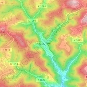
Name: Neulautern topographic map, elevation, terrain.
Average elevation: 1,476 ft
Minimum elevation: 1,073 ft
Maximum elevation: 1,854 ft
Make a donation
Gear up for your next adventure:
As an Amazon Associate, this site earns from qualifying purchases at no extra cost to you.