
Make a donation
Gear up for your next adventure:
As an Amazon Associate, this site earns from qualifying purchases at no extra cost to you.
Monte Arcosu topographic map
Click on the map to display elevation.
Make a donation
Gear up for your next adventure:
As an Amazon Associate, this site earns from qualifying purchases at no extra cost to you.
Monte Arcosu
Monte Arcosu is a mountain in the Sulcis massif, in southern Sardinia, Italy. It has an elevation of 948 metres (3,110 ft).
Make a donation
Gear up for your next adventure:
As an Amazon Associate, this site earns from qualifying purchases at no extra cost to you.
About this map
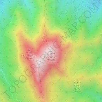
Name: Monte Arcosu topographic map, elevation, terrain.
Location: Monte Arcosu, Siliqua, Casteddu/Cagliari, Sardinia, 09010, Italy (39.19481 8.85676 39.19491 8.85686)
Average elevation: 1,791 ft
Minimum elevation: 699 ft
Maximum elevation: 3,097 ft
Make a donation
Gear up for your next adventure:
As an Amazon Associate, this site earns from qualifying purchases at no extra cost to you.