Geolocate

Conroe topographic map

Click on the map to display elevation.

About this map

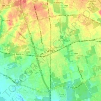
Name: Conroe topographic map, elevation, terrain.

Location: Conroe, Montgomery County, Texas, 77301, United States (30.27188 -95.49605 30.35188 -95.41605)

Average elevation: 197 ft

Minimum elevation: 112 ft

Maximum elevation: 295 ft

Montgomery County trails, hiking, mountain biking, running and outdoor activities

Gear up for your next adventure:

Backpacking Tent - Lightweight and durable tent for multi‑day hikes
🛶Inflatable Kayak - Portable kayak for rivers, lakes, and expeditions
📚USA Hiking Guide Books - Top trail guides and map books
🖼️Topo Map Wall Art - Decorative topographic prints of famous peaks and regions
🔭Telescopic Hiking Pole - Adjustable pole for hiking stability

As an Amazon Associate, this site earns from qualifying purchases at no extra cost to you.