
Make a donation
Gear up for your next adventure:
As an Amazon Associate, this site earns from qualifying purchases at no extra cost to you.
Hampden topographic map
Click on the map to display elevation.
Make a donation
Gear up for your next adventure:
As an Amazon Associate, this site earns from qualifying purchases at no extra cost to you.
Hampden
According to the United States Census Bureau, the town has a total area of 19.6 square miles (51 km2), of which 19.6 square miles (51 km2) is land and 0.05% is water. Hampden is located at the eastern edge of the Connecticut River Valley. Hills rise up to over 1,000 feet (300 m) above sea level, from the valley elevation of 150 to 250 feet (46 to 76 m). The highest peaks are Pine Mt. and Rattlesnake Peak, both at 1,070 feet (330 m). The town has no large bodies of water, but has several brooks which eventually drain into the Connecticut River.
Make a donation
Gear up for your next adventure:
As an Amazon Associate, this site earns from qualifying purchases at no extra cost to you.
About this map
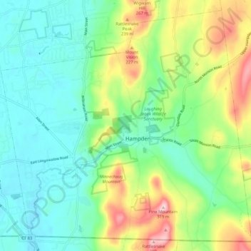
Name: Hampden topographic map, elevation, terrain.
Location: Hampden, Hampden County, Massachusetts, 01036, United States (42.03270 -72.46993 42.10313 -72.36699)
Average elevation: 469 ft
Minimum elevation: 197 ft
Maximum elevation: 1,076 ft
Hampden County trails, hiking, mountain biking, running and outdoor activities
Make a donation
Gear up for your next adventure:
As an Amazon Associate, this site earns from qualifying purchases at no extra cost to you.
Other topographic maps
Click on a map to view its topography, its elevation and its terrain.
Tekoa Mountain
United States > Massachusetts > Hampden County > Montgomery
Tekoa Mountain overlooks the Westfield River Gorge and the Connecticut River Valley. The town of Russell and its villages, Woronoco and Crescent Mills, lie at the foot of the mountain along the Westfield River. From the summit ledges, the cities of Westfield and Springfield, Massachusetts are visible to the…
Average elevation: 791 ft
Make a donation
Gear up for your next adventure:
As an Amazon Associate, this site earns from qualifying purchases at no extra cost to you.
Three Rivers Well Field
United States > Massachusetts > Hampden County > Palmer > Four Corners
Average elevation: 361 ft
Make a donation
Gear up for your next adventure:
As an Amazon Associate, this site earns from qualifying purchases at no extra cost to you.
Make a donation
Gear up for your next adventure:
As an Amazon Associate, this site earns from qualifying purchases at no extra cost to you.
Hampton Village
United States > Massachusetts > Hampden County > Westfield > Hampton Village
Average elevation: 289 ft
Make a donation
Gear up for your next adventure:
As an Amazon Associate, this site earns from qualifying purchases at no extra cost to you.
Indian Orchard
United States > Massachusetts > Hampden County > Springfield > Indian Orchard
Average elevation: 226 ft
Tolland Center
United States > Massachusetts > Hampden County > Tolland > Tolland Center
Average elevation: 1,388 ft
West Agawam
United States > Massachusetts > Hampden County > Agawam > West Agawam
Average elevation: 164 ft
Make a donation
Gear up for your next adventure:
As an Amazon Associate, this site earns from qualifying purchases at no extra cost to you.
North Blandford
United States > Massachusetts > Hampden County > Blandford
Average elevation: 1,407 ft