Geolocate

Howard topographic map

Click on the map to display elevation.

About this map

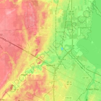
Name: Howard topographic map, elevation, terrain.

Location: Howard, Brown County, Wisconsin, 54313, United States (44.53013 -88.19536 44.59464 -88.01298)

Average elevation: 653 ft

Minimum elevation: 492 ft

Maximum elevation: 791 ft

Brown County trails, hiking, mountain biking, running and outdoor activities

Other topographic maps

Click on a map to view its topography, its elevation and its terrain.

Champion

United States > Wisconsin > Brown County

Average elevation: 771 ft

Greenleaf

United States > Wisconsin > Brown County

Average elevation: 741 ft

Anston

United States > Wisconsin > Brown County

Average elevation: 738 ft

New Franken

United States > Wisconsin > Brown County

Average elevation: 801 ft

Holland

United States > Wisconsin > Brown County

Average elevation: 771 ft

Bellevue

United States > Wisconsin > Brown County > Bellevue > Bellevue

Average elevation: 692 ft

Gear up for your next adventure:

📷Action Camera - Capture your outdoor adventures in HD
🧢Sun Protection Hats - Wide-brimmed and UPF-rated hats for high-altitude sun safety
📚Navigation Handbooks - Master the art of reading topographic maps and using a compass
🦟Ultrasonic Repellers - Create a bug-free zone at your camp or rest stop
🩹Survival Bandages - High‑quality bandages for emergencies

As an Amazon Associate, this site earns from qualifying purchases at no extra cost to you.