
Make a donation
Gear up for your next adventure:
As an Amazon Associate, this site earns from qualifying purchases at no extra cost to you.
West Bend topographic map
Click on the map to display elevation.
Make a donation
Gear up for your next adventure:
As an Amazon Associate, this site earns from qualifying purchases at no extra cost to you.
West Bend
West Bend is in the Kettle Moraine region, and its topography is varied. The glacial activity has formed many kettles and hills throughout the region.
Make a donation
Gear up for your next adventure:
As an Amazon Associate, this site earns from qualifying purchases at no extra cost to you.
About this map
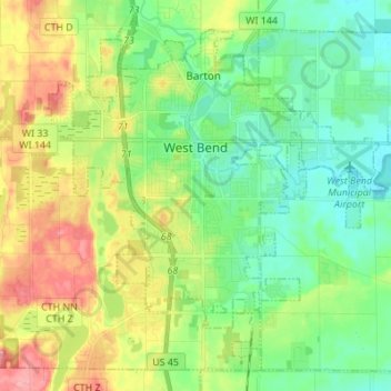
Name: West Bend topographic map, elevation, terrain.
Location: West Bend, Washington County, Wisconsin, United States (43.37029 -88.24651 43.45555 -88.11013)
Average elevation: 978 ft
Minimum elevation: 853 ft
Maximum elevation: 1,201 ft
Washington County trails, hiking, mountain biking, running and outdoor activities
Make a donation
Gear up for your next adventure:
As an Amazon Associate, this site earns from qualifying purchases at no extra cost to you.
Other topographic maps
Click on a map to view its topography, its elevation and its terrain.
Milwaukee River Floodplain Forest State Natural Area
United States > Wisconsin > Washington County
Average elevation: 955 ft
Allenton
United States > Wisconsin > Washington County
Allenton is located at latitude 43.421 and longitude -88.341. The elevation is 958 feet. Allenton has an area of 1.446 square miles (3.75 km2), all of it land. The Rock River cuts through the town.
Average elevation: 1,027 ft