Geolocate

Lichtenstein topographic map

Click on the map to display elevation.

Lichtenstein

The municipality (Gemeinde) of Lichtenstein covers 34.24 square kilometres (13.22 sq mi) of the Reutlingen district, in the state of the Federal Republic of Germany. It is physically located in the middle of the Swabian Jura, on the edge of the Middle Kuppenalb [de] in the valley of the river Echaz. Elevation above sea level ranges from 466 meters (1,529 ft) to 836 meters (2,743 ft) Normalnull.

Wikipedia (CC-BY-SA 3.0)

About this map

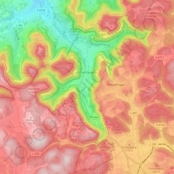
Name: Lichtenstein topographic map, elevation, terrain.

Location: Lichtenstein, Hohenstein, Landkreis Reutlingen, Baden-Württemberg, 72805, Germany (48.38743 9.21681 48.46223 9.31578)

Average elevation: 2,260 ft

Minimum elevation: 1,404 ft

Maximum elevation: 2,831 ft

Other topographic maps

Click on a map to view its topography, its elevation and its terrain.

Honau

Germany > Baden-Württemberg > Landkreis Reutlingen > Honau

Average elevation: 2,323 ft

Engstingen

Germany > Baden-Württemberg > Landkreis Reutlingen

Engstingen is located on the northern edge of the Swabian Jura, at 680–750 metres (2,230–2,460 ft) altitude on the Alb plateau near the Alb edge in the valley of Ur-Lauter, about 15 km south of the town Reutlingen.

Average elevation: 2,421 ft

Gear up for your next adventure:

🌧️Backpack Rain Cover - Keep gear dry in wet weather
📷Action Camera - Capture your outdoor adventures in HD
🏫Relief Map Kits - Hands-on tools for teaching landforms and elevation
🪶Trail Camera - Capture wildlife on your hikes
🧤Hiking Gloves - Protective gloves for rugged trails

As an Amazon Associate, this site earns from qualifying purchases at no extra cost to you.