
Make a donation
Gear up for your next adventure:
As an Amazon Associate, this site earns from qualifying purchases at no extra cost to you.
Piracaia topographic map
Click on the map to display elevation.
Make a donation
Gear up for your next adventure:
As an Amazon Associate, this site earns from qualifying purchases at no extra cost to you.
Piracaia
Piracaia is a municipality in the state of São Paulo in Brazil. The population is 27,462 (2020 est.) in an area of 386 km². The elevation is 792 m. The municipality was established in 1859 as Santo Antônio da Cachoeira, but its name was changed into Piracaia on August 20, 1906.
Make a donation
Gear up for your next adventure:
As an Amazon Associate, this site earns from qualifying purchases at no extra cost to you.
About this map
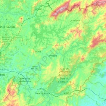
Name: Piracaia topographic map, elevation, terrain.
Average elevation: 2,995 ft
Minimum elevation: 2,129 ft
Maximum elevation: 5,535 ft
Make a donation
Gear up for your next adventure:
As an Amazon Associate, this site earns from qualifying purchases at no extra cost to you.