
Thank you for supporting this site ❤️
Make a donation
Make a donation
Gear up for your next adventure:
As an Amazon Associate, this site earns from qualifying purchases at no extra cost to you.
Indaiatuba topographic map
Click on the map to display elevation.
Thank you for supporting this site ❤️
Make a donation
Make a donation
Gear up for your next adventure:
As an Amazon Associate, this site earns from qualifying purchases at no extra cost to you.
About this map
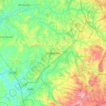
Name: Indaiatuba topographic map, elevation, terrain.
Average elevation: 2,037 ft
Minimum elevation: 1,617 ft
Maximum elevation: 3,005 ft
Thank you for supporting this site ❤️
Make a donation
Make a donation
Gear up for your next adventure:
As an Amazon Associate, this site earns from qualifying purchases at no extra cost to you.
Other topographic maps
Click on a map to view its topography, its elevation and its terrain.
Praça Jd Moacir Arruda
Brasil > São Paulo > Região Metropolitana de Campinas > Indaiatuba
Average elevation: 2,021 ft
Parque e Barragem do Mirim
Brasil > São Paulo > Região Metropolitana de Campinas > Indaiatuba
Average elevation: 1,942 ft