
Make a donation
Gear up for your next adventure:
As an Amazon Associate, this site earns from qualifying purchases at no extra cost to you.
Timimoun topographic map
Click on the map to display elevation.
Make a donation
Gear up for your next adventure:
As an Amazon Associate, this site earns from qualifying purchases at no extra cost to you.
Timimoun
The town of Timimoun lies at an elevation of around 288 metres (945 ft) in the Gourara region of southern Timimoun Province. It is located on the south-eastern side of an oasis which supports the town's population. A sebkha (salt lake) lies further to the northwest, while the plateau of Tademaït rises to the southeast.
Make a donation
Gear up for your next adventure:
As an Amazon Associate, this site earns from qualifying purchases at no extra cost to you.
About this map
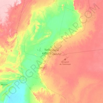
Name: Timimoun topographic map, elevation, terrain.
Location: Timimoun, Timimoun District, Timimoun Province, 1001, Algeria (29.10051 0.06859 29.42051 0.38859)
Average elevation: 899 ft
Minimum elevation: 581 ft
Maximum elevation: 1,214 ft
Make a donation
Gear up for your next adventure:
As an Amazon Associate, this site earns from qualifying purchases at no extra cost to you.
Other topographic maps
Click on a map to view its topography, its elevation and its terrain.