
Thank you for supporting this site ❤️
Make a donation
Make a donation
Gear up for your next adventure:
As an Amazon Associate, this site earns from qualifying purchases at no extra cost to you.
Ablitas topographic map
Click on the map to display elevation.
Thank you for supporting this site ❤️
Make a donation
Make a donation
Gear up for your next adventure:
As an Amazon Associate, this site earns from qualifying purchases at no extra cost to you.
About this map
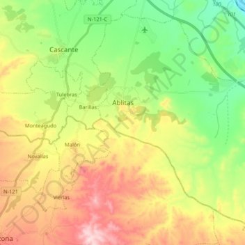
Name: Ablitas topographic map, elevation, terrain.
Location: Ablitas, Erribera / Ribera, Navarre, 31523, Spain (41.90989 -1.66051 42.01667 -1.49885)
Average elevation: 1,283 ft
Minimum elevation: 807 ft
Maximum elevation: 1,932 ft
Thank you for supporting this site ❤️
Make a donation
Make a donation
Gear up for your next adventure:
As an Amazon Associate, this site earns from qualifying purchases at no extra cost to you.