Geolocate

Ablitas topographic map

Click on the map to display elevation.

About this map

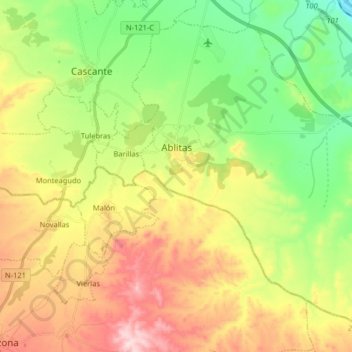
Name: Ablitas topographic map, elevation, terrain.

Location: Ablitas, Erribera / Ribera, Navarre, 31523, Spain (41.90989 -1.66051 42.01667 -1.49885)

Average elevation: 1,283 ft

Minimum elevation: 807 ft

Maximum elevation: 1,932 ft

Gear up for your next adventure:

📖Nature Tracking Books - Learn to track wildlife and terrain
📶Vehicle Signal Boosters - Improve reception in rural areas while driving to trailheads
📷Action Camera - Capture your outdoor adventures in HD
🧣Merino Neck Gaiters - Multi-functional headwear for wind and sun protection
🪶Camp Gear Gift Set - Perfect gift bundle for outdoor fans

As an Amazon Associate, this site earns from qualifying purchases at no extra cost to you.