
Thank you for supporting this site ❤️
Make a donation
Make a donation
Gear up for your next adventure:
As an Amazon Associate, this site earns from qualifying purchases at no extra cost to you.
Sumbilla topographic map
Click on the map to display elevation.
Thank you for supporting this site ❤️
Make a donation
Make a donation
Gear up for your next adventure:
As an Amazon Associate, this site earns from qualifying purchases at no extra cost to you.
About this map
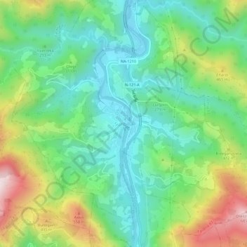
Name: Sumbilla topographic map, elevation, terrain.
Location: Sumbilla, Baztan-Bidasoa, Navarra, 31791, España (43.14410 -1.69102 43.18410 -1.65102)
Average elevation: 942 ft
Minimum elevation: 285 ft
Maximum elevation: 2,277 ft
Thank you for supporting this site ❤️
Make a donation
Make a donation
Gear up for your next adventure:
As an Amazon Associate, this site earns from qualifying purchases at no extra cost to you.