
Thank you for supporting this site ❤️
Make a donation
Make a donation
Gear up for your next adventure:
As an Amazon Associate, this site earns from qualifying purchases at no extra cost to you.
Separassiu topographic map
Click on the map to display elevation.
Thank you for supporting this site ❤️
Make a donation
Make a donation
Gear up for your next adventure:
As an Amazon Associate, this site earns from qualifying purchases at no extra cost to you.
About this map
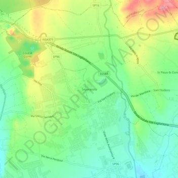
Name: Separassiu topographic map, elevation, terrain.
Location: Separassiu, Quartucciu, Cagliari, Sardegna, 09044, Italia (39.22790 9.25261 39.26790 9.29261)
Average elevation: 148 ft
Minimum elevation: 0 ft
Maximum elevation: 384 ft
Thank you for supporting this site ❤️
Make a donation
Make a donation
Gear up for your next adventure:
As an Amazon Associate, this site earns from qualifying purchases at no extra cost to you.