
Make a donation
Gear up for your next adventure:
As an Amazon Associate, this site earns from qualifying purchases at no extra cost to you.
Crabtree Falls topographic map
Click on the map to display elevation.
Make a donation
Gear up for your next adventure:
As an Amazon Associate, this site earns from qualifying purchases at no extra cost to you.
Crabtree Falls
The Celo USGS topographic quadrangle map labels this falls "Upper Falls", and shows another waterfall some distance away and on another creek being called Crabtree Falls. Originally, the falls was known as Murphy's Falls and a small community was located nearby, including a church and blacksmith shop. When the Blue Ridge Parkway was constructed in the 1930s, the falls was renamed Crabtree Falls by the National Park Service.
Make a donation
Gear up for your next adventure:
As an Amazon Associate, this site earns from qualifying purchases at no extra cost to you.
About this map
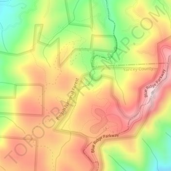
Name: Crabtree Falls topographic map, elevation, terrain.
Location: Crabtree Falls, Yancey County, North Carolina, United States (35.81971 -82.14964 35.81981 -82.14954)
Average elevation: 3,465 ft
Minimum elevation: 2,776 ft
Maximum elevation: 4,019 ft
Yancey County trails, hiking, mountain biking, running and outdoor activities
Make a donation
Gear up for your next adventure:
As an Amazon Associate, this site earns from qualifying purchases at no extra cost to you.
Other topographic maps
Click on a map to view its topography, its elevation and its terrain.