
McBee topographic map
Interactive map
Click on the map to display elevation.
About this map
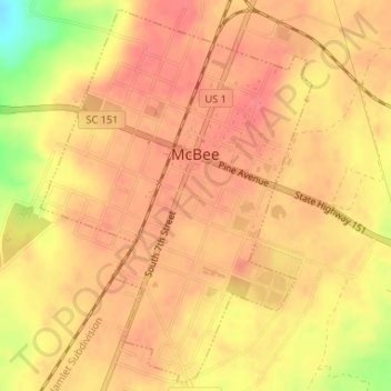
Name: McBee topographic map, elevation, terrain.
Location: McBee, Chesterfield County, South Carolina, United States (34.45294 -80.26901 34.47876 -80.24617)
Average elevation: 449 ft
Minimum elevation: 299 ft
Maximum elevation: 499 ft
Other topographic maps
Click on a map to view its topography, its elevation and its terrain.
Cheraw State Park
United States > South Carolina > Chesterfield County
Cheraw State Park, Chesterfield County, South Carolina, United States
Average elevation: 161 ft
Patrick
United States > South Carolina > Chesterfield County
Patrick, Chesterfield County, South Carolina, United States
Average elevation: 207 ft
Pageland
United States > South Carolina > Chesterfield County
Pageland, Chesterfield County, South Carolina, 29728, United States
Average elevation: 574 ft
Chesterfield
United States > South Carolina > Chesterfield County > Chesterfield
Chesterfield, Chesterfield County, South Carolina, 29709, United States
Average elevation: 259 ft
McBee
United States > South Carolina > Chesterfield County > McBee
McBee, Chesterfield County, South Carolina, 29101, United States
Average elevation: 410 ft
Cheathan Lake Dam D-3219
United States > South Carolina > Chesterfield County
Cheathan Lake Dam D-3219, Chesterfield County, South Carolina, 29520, United States
Average elevation: 141 ft
Cheraw
United States > South Carolina > Chesterfield County
Cheraw, Chesterfield County, South Carolina, 29520, United States
Average elevation: 121 ft