
Make a donation
Gear up for your next adventure:
As an Amazon Associate, this site earns from qualifying purchases at no extra cost to you.
Cheraw State Park topographic map
Click on the map to display elevation.
Make a donation
Gear up for your next adventure:
As an Amazon Associate, this site earns from qualifying purchases at no extra cost to you.
About this map
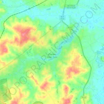
Name: Cheraw State Park topographic map, elevation, terrain.
Average elevation: 161 ft
Minimum elevation: 69 ft
Maximum elevation: 325 ft
Chesterfield County trails, hiking, mountain biking, running and outdoor activities
Make a donation
Gear up for your next adventure:
As an Amazon Associate, this site earns from qualifying purchases at no extra cost to you.
Other topographic maps
Click on a map to view its topography, its elevation and its terrain.
Chesterfield
United States > South Carolina > Chesterfield County > Chesterfield
Average elevation: 259 ft
Make a donation
Gear up for your next adventure:
As an Amazon Associate, this site earns from qualifying purchases at no extra cost to you.
Cheathan Lake Dam D-3219
United States > South Carolina > Chesterfield County
Average elevation: 141 ft