Geolocate

Acacia Ridge topographic map

Click on the map to display elevation.

About this map

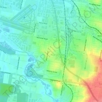
Name: Acacia Ridge topographic map, elevation, terrain.

Location: Acacia Ridge, Brisbane City, Queensland, Australia (-27.59908 152.99553 -27.56933 153.04588)

Average elevation: 85 ft

Minimum elevation: 10 ft

Maximum elevation: 262 ft

Other topographic maps

Click on a map to view its topography, its elevation and its terrain.

Willmington Park

Australia > Queensland > Brisbane City

Average elevation: 121 ft

Mount Gravatt

Australia > Queensland > Brisbane City

Average elevation: 230 ft

Ithaca

Australia > Queensland > Brisbane City > Ithaca

Average elevation: 102 ft

Gear up for your next adventure:

🛏️Cold Weather Sleeping Bag - Warm sleeping bag for cold conditions
🦶Hiking Gaiters - Keep debris and water out of your boots
🪓Survival Multi‑Tool - Versatile tool for camp and trail tasks
🪶Multi‑Purpose Knife - Useful blade for camp and trail
🌲Outdoor Survival Books - Best books on survival skills

As an Amazon Associate, this site earns from qualifying purchases at no extra cost to you.