
Make a donation
Gear up for your next adventure:
As an Amazon Associate, this site earns from qualifying purchases at no extra cost to you.
La Bourgarie topographic map
Click on the map to display elevation.
Make a donation
Gear up for your next adventure:
As an Amazon Associate, this site earns from qualifying purchases at no extra cost to you.
About this map
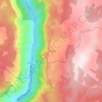
Name: La Bourgarie topographic map, elevation, terrain.
Average elevation: 2,680 ft
Minimum elevation: 1,296 ft
Maximum elevation: 3,488 ft
Make a donation
Gear up for your next adventure:
As an Amazon Associate, this site earns from qualifying purchases at no extra cost to you.
Other topographic maps
Click on a map to view its topography, its elevation and its terrain.
Les Vignes
France > Occitanie > Lozère > Massegros Causses Gorges
Le village est construit au bord du Tarn, sur les flancs du plateau calcaire du causse de Sauveterre, face au causse Méjean, à environ 400 m d'altitude.
Average elevation: 2,789 ft
Saint-Georges-de-Lévéjac
France > Occitanie > Lozère > Massegros Causses Gorges
Average elevation: 2,835 ft
Make a donation
Gear up for your next adventure:
As an Amazon Associate, this site earns from qualifying purchases at no extra cost to you.