Geolocate

Bonham topographic map

Click on the map to display elevation.

About this map

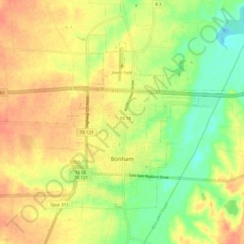
Name: Bonham topographic map, elevation, terrain.

Location: Bonham, Fannin County, Texas, 75418, United States (33.56570 -96.23367 33.62265 -96.13807)

Average elevation: 604 ft

Minimum elevation: 512 ft

Maximum elevation: 676 ft

Fannin County trails, hiking, mountain biking, running and outdoor activities

Other topographic maps

Click on a map to view its topography, its elevation and its terrain.

Boyd

United States > Texas > Fannin County

Average elevation: 604 ft

Post Oak

United States > Texas > Fannin County

Average elevation: 587 ft

Ravenna

United States > Texas > Fannin County > Ravenna

Average elevation: 581 ft

Randolph

United States > Texas > Fannin County

Average elevation: 659 ft

Indian Creek

United States > Texas > Fannin County > Trenton

Average elevation: 712 ft

Gear up for your next adventure:

❄️Traction Cleats - Prevent slips on icy trails during winter hikes
Solar GPS Watches - Advanced multisport watches with built-in topographic maps
🦟Ultrasonic Repellers - Create a bug-free zone at your camp or rest stop
🎒Hydration Pack - Hands‑free water reservoir for long hikes
🎒Waterproof Dry Bags - Keep your electronics and maps dry inside your pack

As an Amazon Associate, this site earns from qualifying purchases at no extra cost to you.