
Make a donation
Gear up for your next adventure:
As an Amazon Associate, this site earns from qualifying purchases at no extra cost to you.
Creppe topographic map
Click on the map to display elevation.
Make a donation
Gear up for your next adventure:
As an Amazon Associate, this site earns from qualifying purchases at no extra cost to you.
Creppe
Distant de 3 km de la ville de Spa, Creppe, entouré de massifs boisés, est situé sur le plateau à une altitude d'environ 380 m soit 130 m au-dessus de l'altitude de Spa. Il avoisine le hameau de Winamplanche.
Make a donation
Gear up for your next adventure:
As an Amazon Associate, this site earns from qualifying purchases at no extra cost to you.
About this map
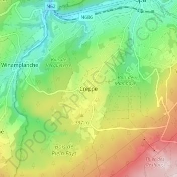
Name: Creppe topographic map, elevation, terrain.
Location: Creppe, Spa, Verviers, Liège, Wallonie, 4900, Belgique (50.45183 5.82419 50.49183 5.86419)
Average elevation: 1,158 ft
Minimum elevation: 719 ft
Maximum elevation: 1,841 ft
Make a donation
Gear up for your next adventure:
As an Amazon Associate, this site earns from qualifying purchases at no extra cost to you.