
Make a donation
Gear up for your next adventure:
As an Amazon Associate, this site earns from qualifying purchases at no extra cost to you.
Hundwil topographic map
Click on the map to display elevation.
Make a donation
Gear up for your next adventure:
As an Amazon Associate, this site earns from qualifying purchases at no extra cost to you.
Hundwil
La commune de Hundwil est située au pied du Säntis. Son altitude est comprise entre 655 mètres, au bord de la rivière Urnäsch, et 2 501 mètres, au sommet du Säntis. Le col de la Schwägalp, station de départ du téléphérique du Säntis, se trouve également sur le territoire communal.
Make a donation
Gear up for your next adventure:
As an Amazon Associate, this site earns from qualifying purchases at no extra cost to you.
About this map
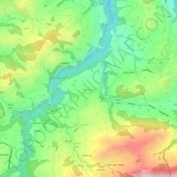
Name: Hundwil topographic map, elevation, terrain.
Location: Hundwil, Hinterland, Appenzell Rhodes-Extérieures, 9064, Suisse (47.34592 9.29818 47.38592 9.33818)
Average elevation: 2,726 ft
Minimum elevation: 2,093 ft
Maximum elevation: 3,724 ft
Make a donation
Gear up for your next adventure:
As an Amazon Associate, this site earns from qualifying purchases at no extra cost to you.