Geolocate

Raymond topographic map

Click on the map to display elevation.

About this map

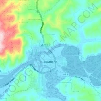
Name: Raymond topographic map, elevation, terrain.

Location: Raymond, Pacific County, Washington, United States (46.66562 -123.77837 46.71792 -123.70104)

Average elevation: 213 ft

Minimum elevation: -39 ft

Maximum elevation: 1,132 ft

Pacific County trails, hiking, mountain biking, running and outdoor activities

Other topographic maps

Click on a map to view its topography, its elevation and its terrain.

Oceanside

United States > Washington > Pacific County

Average elevation: 13 ft

Heather

United States > Washington > Pacific County > Heather

Average elevation: 66 ft

Gear up for your next adventure:

🔋Solar Power Banks - Keep your GPS and phone charged in remote wilderness areas
🧢Sun Protection Hats - Wide-brimmed and UPF-rated hats for high-altitude sun safety
🧭Hiking Compass - Precision compass for reliable navigation in the wilderness
📱Heavy-Duty Phone Cases - Drop-proof and waterproof protection for outdoor navigation
🏕️Family Camping Gear - Essentials for group camping trips

As an Amazon Associate, this site earns from qualifying purchases at no extra cost to you.