Geolocate

Lyons topographic map

Click on the map to display elevation.

About this map

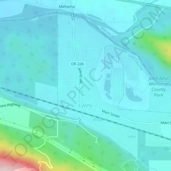
Name: Lyons topographic map, elevation, terrain.

Location: Lyons, Linn County, Oregon, United States (44.76637 -122.62139 44.78894 -122.58380)

Average elevation: 732 ft

Minimum elevation: 597 ft

Maximum elevation: 1,624 ft

Linn County trails, hiking, mountain biking, running and outdoor activities

Other topographic maps

Click on a map to view its topography, its elevation and its terrain.

Tamolitch Falls

United States > Oregon > Linn County

Average elevation: 2,864 ft

Clear Lake

United States > Oregon > Linn County

Average elevation: 3,291 ft

Cascadia

United States > Oregon > Linn County

Average elevation: 1,362 ft

Gear up for your next adventure:

🏕️Family Camping Gear - Essentials for group camping trips
🔋Rechargeable Batteries - Power up your outdoor devices
🛡️Bear Spray Outdoor - Protection in bear country hikes
🧣Merino Neck Gaiters - Multi-functional headwear for wind and sun protection
🏥Hiking First Aid Kits - Comprehensive medical kits for remote trail injuries

As an Amazon Associate, this site earns from qualifying purchases at no extra cost to you.