
Make a donation
Gear up for your next adventure:
As an Amazon Associate, this site earns from qualifying purchases at no extra cost to you.
Stavelot topographic map
Click on the map to display elevation.
Make a donation
Gear up for your next adventure:
As an Amazon Associate, this site earns from qualifying purchases at no extra cost to you.
Stavelot
Stavelot has an oceanic climate influenced by its high elevation and inland position towards a more continental type by Belgian standards. Being located at a lower elevation than neighbouring village Malmedy at the other end of the original layout of the Spa-Francorchamps race track, Stavelot is slightly milder, drier and sunnier than Malmedy year round.
Make a donation
Gear up for your next adventure:
As an Amazon Associate, this site earns from qualifying purchases at no extra cost to you.
About this map
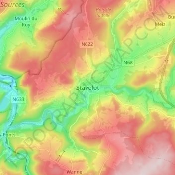
Name: Stavelot topographic map, elevation, terrain.
Location: Stavelot, Verviers, Liège, Wallonia, 4970, Belgium (50.35424 5.89103 50.43424 5.97103)
Average elevation: 1,316 ft
Minimum elevation: 719 ft
Maximum elevation: 1,919 ft
Make a donation
Gear up for your next adventure:
As an Amazon Associate, this site earns from qualifying purchases at no extra cost to you.
Other topographic maps
Click on a map to view its topography, its elevation and its terrain.