
Thank you for supporting this site ❤️
Make a donation
Make a donation
Gear up for your next adventure:
As an Amazon Associate, this site earns from qualifying purchases at no extra cost to you.
Steinbach topographic map
Click on the map to display elevation.
Thank you for supporting this site ❤️
Make a donation
Make a donation
Gear up for your next adventure:
As an Amazon Associate, this site earns from qualifying purchases at no extra cost to you.
About this map
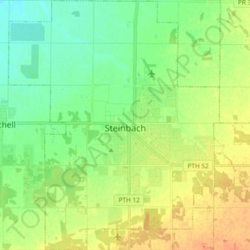
Name: Steinbach topographic map, elevation, terrain.
Location: Steinbach, Division No. 2, Manitoba, Canada (49.48797 -96.75618 49.57488 -96.64279)
Average elevation: 860 ft
Minimum elevation: 810 ft
Maximum elevation: 922 ft
Thank you for supporting this site ❤️
Make a donation
Make a donation
Gear up for your next adventure:
As an Amazon Associate, this site earns from qualifying purchases at no extra cost to you.
Other topographic maps
Click on a map to view its topography, its elevation and its terrain.
Ile des Chenes
Canada > Manitoba > Division No. 2 > Rural Municipality of Ritchot
Average elevation: 774 ft