
Make a donation
Gear up for your next adventure:
As an Amazon Associate, this site earns from qualifying purchases at no extra cost to you.
Tolmezzo topographic map
Click on the map to display elevation.
Make a donation
Gear up for your next adventure:
As an Amazon Associate, this site earns from qualifying purchases at no extra cost to you.
Tolmezzo
Tolmezzo is located at the foot of the Strabut Mountain, between the Tagliamento River and the Bût stream. Nearby is the Mount Amariana, elevation 1,906 metres (6,253 ft). The commune also includes the five frazioni of Cadunea (Friulian: Cjadugnee), Caneva (Cjanive), Casanova (Cjasegnove), Fusea (Fusee), Illegio (Dieç), Imponzo (Dimponç).
Make a donation
Gear up for your next adventure:
As an Amazon Associate, this site earns from qualifying purchases at no extra cost to you.
About this map
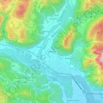
Name: Tolmezzo topographic map, elevation, terrain.
Location: Tolmezzo, Udine, Friuli-Venezia Giulia, 33028, Italy (46.36537 12.97584 46.44537 13.05584)
Average elevation: 1,847 ft
Minimum elevation: 863 ft
Maximum elevation: 5,026 ft
Make a donation
Gear up for your next adventure:
As an Amazon Associate, this site earns from qualifying purchases at no extra cost to you.