
San Agustín Tetlama topographic map
Interactive map
Click on the map to display elevation.
About this map
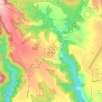
Name: San Agustín Tetlama topographic map, elevation, terrain.
Location: San Agustín Tetlama, Temixco, Morelos, 62595, México (18.81086 -99.30413 18.85086 -99.26413)
Average elevation: 4,114 ft
Minimum elevation: 3,678 ft
Maximum elevation: 4,505 ft
Other topographic maps
Click on a map to view its topography, its elevation and its terrain.
Lázaro Cárdenas del Río
Lázaro Cárdenas del Río, Temixco, Morelos, 62587, México
Average elevation: 4,134 ft
Pueblo Viejo
Pueblo Viejo, Temixco, Morelos, 62588, México
Average elevation: 4,432 ft