Geolocate

Scalpay topographic map

Click on the map to display elevation.

About this map

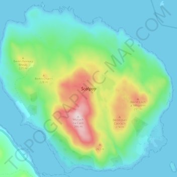
Name: Scalpay topographic map, elevation, terrain.

Location: Scalpay, Highland, Scotland, IV49 9BS, United Kingdom (57.27365 -6.02294 57.32537 -5.91986)

Average elevation: 292 ft

Minimum elevation: 0 ft

Maximum elevation: 1,293 ft

Other topographic maps

Click on a map to view its topography, its elevation and its terrain.

Inverness

United Kingdom > Scotland > Highland

Average elevation: 535 ft

Aviemore

United Kingdom > Scotland > Highland

Average elevation: 1,086 ft

Skye

United Kingdom > Scotland > Highland

Beyond Loch Snizort to the west of Trotternish is the Waternish peninsula, which ends in Ardmore Point's double rock arch. Duirinish peninsula is separated from Waternish by Loch Dunvegan, which contains the island of Isay. It is ringed by sea cliffs that reach 296 metres (971 feet) on the west at Waterstein…

Average elevation: 207 ft

Scottish Highlands

United Kingdom > Scotland > Highland

The Scottish Highlands are renowned for their rugged, mountainous terrain that dominates much of the region. Stretching across the northern and central parts of Scotland, the landscape is shaped by ancient geological forces, including the Caledonian Orogeny, which caused significant tectonic collisions…

Average elevation: 2,976 ft

Fort William

United Kingdom > Scotland > Highland

Fort William has an oceanic climate (Cfb) with moderate, but generally cool, temperatures and abundant precipitation. In the towns immediate vicinity, there are significant variations in elevation, which leads to some uninhabited areas near the town having a subpolar oceanic climate (Cfc), or, at the absolute…

Average elevation: 400 ft

Strathpeffer

United Kingdom > Scotland > Highland

It lies in a strath 5 miles (8 km) west of Dingwall, with the elevation ranging from 60 to 120 m (200 to 400 ft) above sea level. Sheltered on the west and north, it has a comparatively dry and warm climate.

Average elevation: 417 ft

Arisaig

United Kingdom > Scotland > Highland

Average elevation: 177 ft

Coylumbridge

United Kingdom > Scotland > Highland > Aviemore

Average elevation: 860 ft

Mellon Charles

United Kingdom > Scotland > Highland

Average elevation: 98 ft

Ben Nevis

United Kingdom > Scotland > Highland

Ben Nevis has a highland (alpine) maritime (oceanic) polar climate (ET climate in the Köppen classification). Ben Nevis's elevation, maritime location and topography frequently lead to cool and cloudy weather conditions, which can pose a danger to ill-equipped walkers. According to the observations carried…

Average elevation: 2,992 ft

Forsinard

United Kingdom > Scotland > Highland

Average elevation: 561 ft

Golspie

United Kingdom > Scotland > Highland

Average elevation: 200 ft

Ben Loyal

United Kingdom > Scotland > Highland

Average elevation: 1,447 ft

Loch Shiel

United Kingdom > Scotland > Highland > Acharacle

Average elevation: 951 ft

Eilean Shona

United Kingdom > Scotland > Highland

Average elevation: 161 ft

Ardnamurchan

United Kingdom > Scotland > Highland

The north western corner of Ardnamurchan consists of a lopolith (previously interpreted as a ring dyke) that has been exposed at the surface. Evidence for such a structure can be identified from the phenocrysts in the rock exposures around the area of interest which show plagioclase crystals aligned towards…

Average elevation: 240 ft

Aonach Mòr

United Kingdom > Scotland > Highland

Aonach Mòr is a mountain in the Scottish Highlands. It is located about two miles (three kilometres) northeast of Ben Nevis on the south side of Glen Spean, near Fort William. The mountain has a summit elevation of 4,006 ft (1,221 m) and is classified as a Munro.

Average elevation: 2,946 ft

Loch Morlich

United Kingdom > Scotland > Highland > Glenmore

Average elevation: 1,138 ft

Càrn Eige

United Kingdom > Scotland > Highland

Carn Eighe (Scottish Gaelic: Càrn Èite) is a mountain in the Northwest Highlands of Scotland. Rising to 1,183 metres (3,881 ft) above sea level, it is the highest mountain in Scotland north of the Great Glen, the twelfth-highest in the British Isles, and, in terms of relative height (topographic prominence),…

Average elevation: 2,844 ft

Mam Sodhail

United Kingdom > Scotland > Highland

Average elevation: 2,874 ft

Ben Klibreck

United Kingdom > Scotland > Highland

Ben Klibreck (Scottish Gaelic: Beinn Chlìbric) is a Scottish mountain located in central Sutherland. It is an isolated mountain, rising above a large area of moorland. The highest point, Meall nan Con (the mound of the dogs), rises to 962 metres (3,156 ft) elevation and is therefore the second most northerly…

Average elevation: 1,808 ft

Sgùrr na Sgine

United Kingdom > Scotland > Highland

Average elevation: 1,985 ft

Gleouraich

United Kingdom > Scotland > Highland

Average elevation: 2,044 ft

Fort Augustus

United Kingdom > Scotland > Highland

As with most of the British Isles and Scotland, Fort Augustus has an oceanic climate (Köppen: Cfb) with cool summers and mild winters. Like a lot of the surrounding area, sunshine levels are low at around 1,005 hours per annum and temperatures are unpredictable – Fort Augustus holds the UK's joint lowest…

Average elevation: 377 ft

Kinlochleven

United Kingdom > Scotland > Highland

Work on the dam and water supply system began in 1905 and was completed in 1907. The hydro-electric scheme was constructed for the British Aluminium Company and was designed by engineer brothers Patrick and Charles Meik. The chief assistant resident engineer on the project was a young William Halcrow. The…

Average elevation: 1,004 ft

Rosemarkie

United Kingdom > Scotland > Highland

Average elevation: 144 ft

the Black Isle

United Kingdom > Scotland > Highland

Average elevation: 269 ft

Raddery

United Kingdom > Scotland > Highland > Fortrose

Average elevation: 423 ft

Corpach

United Kingdom > Scotland > Highland

Average elevation: 272 ft

Ardnarff

United Kingdom > Scotland > Highland

Average elevation: 512 ft

Knoydart

United Kingdom > Scotland > Highland > Inverie

Average elevation: 709 ft

Langdale

United Kingdom > Scotland > Highland

Average elevation: 377 ft

Davochfin

United Kingdom > Scotland > Highland > Dornoch

Average elevation: 43 ft

Melvaig

United Kingdom > Scotland > Highland

Average elevation: 295 ft

Invermoriston

United Kingdom > Scotland > Highland

Average elevation: 696 ft

Sgùrr Alasdair

United Kingdom > Scotland > Highland

Average elevation: 1,890 ft

Newtonmore

United Kingdom > Scotland > Highland

Newtonmore is located within the Cairngorms National Park, approximately 3 miles (5 km) southwest of Kingussie and 15 miles (24 km) southwest of Aviemore. It is on the northeastern bank of the River Spey, between the River Calder and the Allt Lairaidh, at an altitude of approximately 250 metres (820 ft).

Average elevation: 928 ft

Glencoe

United Kingdom > Scotland > Highland

Average elevation: 374 ft

Avoch

United Kingdom > Scotland > Highland

Average elevation: 164 ft

Scotscalder

United Kingdom > Scotland > Highland

Average elevation: 236 ft

Wick

United Kingdom > Scotland > Highland

Average elevation: 66 ft

Kingussie

United Kingdom > Scotland > Highland

Average elevation: 1,109 ft

Lairg

United Kingdom > Scotland > Highland

Average elevation: 423 ft

Golspie Burn

United Kingdom > Scotland > Highland > Golspie

Average elevation: 486 ft

Loch Morar

United Kingdom > Scotland > Highland > Morar

Loch Morar (Scottish Gaelic: Loch Mòrair) is a freshwater loch in Lochaber, Highland, Scotland. It is the fifth-largest loch by surface area in Scotland, at 26.7 km2 (10.3 sq mi), and the deepest freshwater body in the British Isles with a maximum depth of 310 m (1,017 ft). The loch was created by glacial…

Average elevation: 387 ft

Insh

United Kingdom > Scotland > Highland

Average elevation: 902 ft

Lyth

United Kingdom > Scotland > Highland

Average elevation: 95 ft

Caol

United Kingdom > Scotland > Highland

Average elevation: 125 ft

Scottish Highlands

United Kingdom > Scotland > Highland

The entire region was covered by ice sheets during the Pleistocene ice ages, save perhaps for a few nunataks. The complex geomorphology includes incised valleys and lochs carved by the action of mountain streams and ice, and a topography of irregularly distributed mountains whose summits have similar heights…

Average elevation: 2,976 ft

Glasnakille

United Kingdom > Scotland > Highland

Average elevation: 128 ft

Ballachulish

United Kingdom > Scotland > Highland

Average elevation: 525 ft

Clachtoll

United Kingdom > Scotland > Highland

Average elevation: 125 ft

Brae Roy Lodge

United Kingdom > Scotland > Highland

Average elevation: 1,217 ft

Grampian Mountains

United Kingdom > Scotland > Highland

Average elevation: 2,543 ft

Sgùrr na Banachdich

United Kingdom > Scotland > Highland

Average elevation: 1,844 ft

Staffin

United Kingdom > Scotland > Highland

Average elevation: 138 ft

Dounreay

United Kingdom > Scotland > Highland

Average elevation: 118 ft

Inverinate

United Kingdom > Scotland > Highland

Average elevation: 610 ft

Tongue

United Kingdom > Scotland > Highland

Average elevation: 299 ft

Knockdee

United Kingdom > Scotland > Highland

Average elevation: 217 ft

North Watten

United Kingdom > Scotland > Highland

Average elevation: 167 ft

Loch Tarff

United Kingdom > Scotland > Highland

Average elevation: 1,056 ft

Poolewe

United Kingdom > Scotland > Highland

Average elevation: 190 ft

Altnaharra

United Kingdom > Scotland > Highland

Average elevation: 413 ft

Fearnmore

United Kingdom > Scotland > Highland

Average elevation: 72 ft

Milovaig

United Kingdom > Scotland > Highland

Average elevation: 236 ft

Sgùrr nan Gillean

United Kingdom > Scotland > Highland

Average elevation: 1,627 ft

Tarvie

United Kingdom > Scotland > Highland

Average elevation: 443 ft

The Storr

United Kingdom > Scotland > Highland

Average elevation: 1,299 ft

Halkirk

United Kingdom > Scotland > Highland

Average elevation: 161 ft

Foyers

United Kingdom > Scotland > Highland

Average elevation: 407 ft

Spean Bridge

United Kingdom > Scotland > Highland

Average elevation: 463 ft

Prince Charles's Stone

United Kingdom > Scotland > Highland > Tomatin > Raigbeg

Average elevation: 1,040 ft

Ardgour

United Kingdom > Scotland > Highland

Average elevation: 771 ft

Gillock

United Kingdom > Scotland > Highland > Wick

Average elevation: 72 ft

Grantown-on-Spey

United Kingdom > Scotland > Highland

Average elevation: 889 ft

Farrmheall

United Kingdom > Scotland > Highland

Average elevation: 922 ft

Laide

United Kingdom > Scotland > Highland

Average elevation: 154 ft

Gartymore

United Kingdom > Scotland > Highland > Portgower

Average elevation: 308 ft

Leanachan Forest

United Kingdom > Scotland > Highland > Torlundy

Average elevation: 328 ft

Aultbea

United Kingdom > Scotland > Highland

Average elevation: 144 ft

Portree

United Kingdom > Scotland > Highland

Average elevation: 397 ft

Kilbride

United Kingdom > Scotland > Highland

Average elevation: 381 ft

Corry Bruoch Beg

United Kingdom > Scotland > Highland

Average elevation: 1,099 ft

Kylesku

United Kingdom > Scotland > Highland

Average elevation: 269 ft

Scourie

United Kingdom > Scotland > Highland

Average elevation: 167 ft

Torridon

United Kingdom > Scotland > Highland

Average elevation: 774 ft

Glenachulish

United Kingdom > Scotland > Highland

Average elevation: 666 ft

Acharacle

United Kingdom > Scotland > Highland

Average elevation: 151 ft

Dundreggan

United Kingdom > Scotland > Highland

Average elevation: 820 ft

Achnahaird

United Kingdom > Scotland > Highland

Average elevation: 131 ft

Drumchork

United Kingdom > Scotland > Highland > Aultbea

Average elevation: 164 ft

Kinlochewe

United Kingdom > Scotland > Highland

Average elevation: 502 ft

Nairn

United Kingdom > Scotland > Highland

Average elevation: 59 ft

Nethy Bridge

United Kingdom > Scotland > Highland

Average elevation: 755 ft

Thrumster

United Kingdom > Scotland > Highland

Average elevation: 200 ft

Rosehall

United Kingdom > Scotland > Highland

Average elevation: 295 ft

Gairloch

United Kingdom > Scotland > Highland

Average elevation: 253 ft

Gear up for your next adventure:

🎒Waterproof Dry Bags - Keep your electronics and maps dry inside your pack
🧭Compass with Lanyard - Easy‑carry compass for navigation
🔦Powerful Headlamps - Ultra-bright hands-free lighting for night navigation
🧭Map Reading Tools - Tools and kits for map navigation
🧭Outdoor Navigation Book - Learn advanced navigation skills

As an Amazon Associate, this site earns from qualifying purchases at no extra cost to you.