Geolocate

Taylor topographic map

Interactive map

Click on the map to display elevation.

About this map

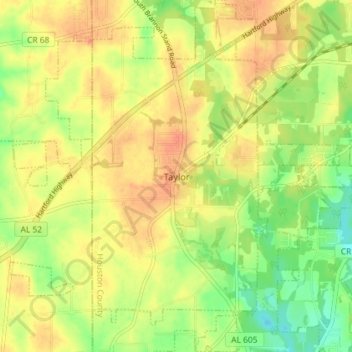
Name: Taylor topographic map, elevation, terrain.

Location: Taylor, Houston County, Alabama, United States (31.13410 -85.49516 31.19591 -85.44957)

Average elevation: 289 ft

Minimum elevation: 200 ft

Maximum elevation: 361 ft

Houston County trails, hiking, mountain biking, running and outdoor activities

Other topographic maps

Click on a map to view its topography, its elevation and its terrain.

Seminole Heights

United States > Alabama > Houston County

Average elevation: 266 ft

Rock Creek Park

United States > Alabama > Houston County > Dothan

Average elevation: 299 ft

Kelly Springs

United States > Alabama > Houston County > Dothan

Average elevation: 318 ft

Silver Meadows

United States > Alabama > Houston County > Dothan

Average elevation: 295 ft

Hodgesville

United States > Alabama > Houston County

Average elevation: 210 ft

Ashford

United States > Alabama > Houston County > Ashford

Average elevation: 253 ft

Crosby

United States > Alabama > Houston County > Crosby

Average elevation: 148 ft

Dothan

United States > Alabama > Houston County > Dothan

Average elevation: 272 ft