
Make a donation
Gear up for your next adventure:
As an Amazon Associate, this site earns from qualifying purchases at no extra cost to you.
Berbegal topographic map
Click on the map to display elevation.
Make a donation
Gear up for your next adventure:
As an Amazon Associate, this site earns from qualifying purchases at no extra cost to you.
About this map
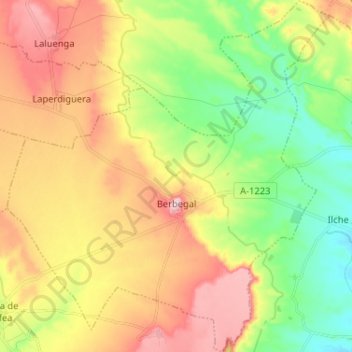
Name: Berbegal topographic map, elevation, terrain.
Location: Berbegal, Somontano de Barbastro, Huesca, Aragón, España (41.92088 -0.06496 42.01695 0.05361)
Average elevation: 1,319 ft
Minimum elevation: 991 ft
Maximum elevation: 1,713 ft
Make a donation
Gear up for your next adventure:
As an Amazon Associate, this site earns from qualifying purchases at no extra cost to you.
Other topographic maps
Click on a map to view its topography, its elevation and its terrain.
Make a donation
Gear up for your next adventure:
As an Amazon Associate, this site earns from qualifying purchases at no extra cost to you.
Embalse de El Grado
España > Aragón > Somontano de Barbastro > Sobrarbe > El Grado
Average elevation: 2,208 ft
Castejón del Puente
España > Aragón > Somontano de Barbastro > Castejón del Puente > Castejón del Puente
Average elevation: 1,040 ft