Geolocate

Garstang topographic map

Click on the map to display elevation.

About this map

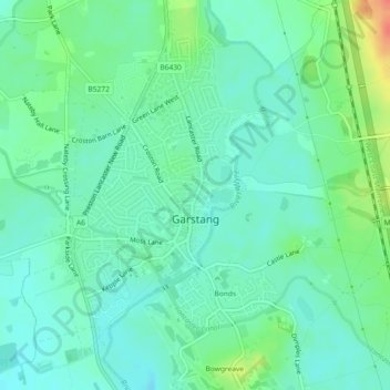
Name: Garstang topographic map, elevation, terrain.

Location: Garstang, Borough of Wyre, Lancashire, England, United Kingdom (53.89262 -2.79394 53.91382 -2.76443)

Average elevation: 79 ft

Minimum elevation: 33 ft

Maximum elevation: 194 ft

Other topographic maps

Click on a map to view its topography, its elevation and its terrain.

Forton

United Kingdom > England > Lancashire > Borough of Wyre

Average elevation: 98 ft

Inskip

United Kingdom > England > Lancashire > Borough of Wyre

Average elevation: 46 ft

Gear up for your next adventure:

👖Convertible Hiking Pants - Versatile zip-off pants for changing altitudes and temperatures
🪓Survival Multi‑Tool - Versatile tool for camp and trail tasks
🪶Thermal Camp Blanket - Extra warmth for cold nights
📡Handheld GPS Device - Reliable handheld GPS for outdoor navigation
👟Trail Running Shoes - Lightweight shoes for trail runners

As an Amazon Associate, this site earns from qualifying purchases at no extra cost to you.