Geolocate

Reno topographic map

Click on the map to display elevation.

Reno

Reno is characterized by its diverse topography, which is shaped by its elevation and the surrounding mountain ranges. Situated at an average elevation of approximately 4,500 feet (about 1,370 meters), the city is nestled in a high desert region that features a mix of flat valleys and gently rolling hills​. To the west, the Sierra Nevada mountains rise dramatically, with peaks often exceeding 10,000 feet (3,048 meters)​. This mountainous backdrop contributes to a striking contrast against the lower elevations of the city and nearby valleys, such as the Truckee River Valley​. The area is also dotted with lakes and parks, providing recreational opportunities amidst its rugged terrain​. Overall, Reno's topography combines arid landscapes with stunning mountainous scenery, making it a unique destination for both residents and visitors.

About this map

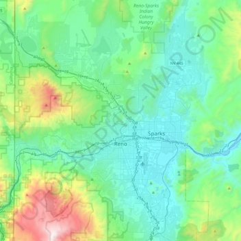
Name: Reno topographic map, elevation, terrain.

Location: Reno, Washoe County, Nevada, United States (39.39243 -120.00233 39.72344 -119.69935)

Average elevation: 5,413 ft

Minimum elevation: 4,318 ft

Maximum elevation: 9,875 ft

Washoe County trails, hiking, mountain biking, running and outdoor activities

Other topographic maps

Click on a map to view its topography, its elevation and its terrain.

Verdi

United States > Nevada > Washoe County

Average elevation: 5,062 ft

Mount Rose

United States > Nevada > Washoe County

Average elevation: 9,577 ft

Gerlach

United States > Nevada > Washoe County

According to the United States Census Bureau, the Gerlach CDP has a total area of 3.1 square miles (8.0 km2), all land. Its elevation is 3,944 ft (1,202 m). Gerlach is approximately 100 miles (160 km) north of Reno, Nevada.

Average elevation: 3,963 ft

Red Rock

United States > Nevada > Washoe County

Average elevation: 4,803 ft

Palomino Valley

United States > Nevada > Washoe County

Average elevation: 4,370 ft

State Line Peak

United States > Nevada > Washoe County

Average elevation: 6,952 ft

Pyramid

United States > Nevada > Washoe County

Average elevation: 4,173 ft

Lemmon Valley

United States > Nevada > Washoe County

Average elevation: 5,049 ft

Golden Valley Park

United States > Nevada > Washoe County > Reno

Average elevation: 5,171 ft

Tohakum Peak

United States > Nevada > Washoe County

Average elevation: 6,883 ft

Lemmon Valley

United States > Nevada > Washoe County

Average elevation: 5,049 ft

Highland Reservoir

United States > Nevada > Washoe County > Reno

Average elevation: 4,665 ft

Mount Rose

United States > Nevada > Washoe County

Average elevation: 9,577 ft

Red Rock

United States > Nevada > Washoe County

Average elevation: 4,803 ft

Sand Pass

United States > Nevada > Washoe County

Average elevation: 4,117 ft

Mount Rose

United States > Nevada > Washoe County

Average elevation: 9,577 ft

Verdi

United States > Nevada > Washoe County

Average elevation: 5,062 ft

Cold Springs

United States > Nevada > Washoe County

Average elevation: 5,161 ft

Incline Village

United States > Nevada > Washoe County

Average elevation: 7,136 ft

Gear up for your next adventure:

📱Solar Portable Charger - Solar power bank for charging devices off‑grid
Backpacking Tents - Weight-optimized shelters for multi-day topographic surveys
🔊Portable Camp Speaker - Music and alerts at camp
🚗GPS Dash Cams - Record your scenic drives through mountain passes and canyons
🕶️GPS Smartphone Mount - Secure mount for phone navigation

As an Amazon Associate, this site earns from qualifying purchases at no extra cost to you.