
Satara Rest Camp topographic map
Click on the map to display elevation.
About this map
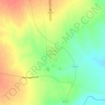
Name: Satara Rest Camp topographic map, elevation, terrain.
Average elevation: 879 ft
Minimum elevation: 791 ft
Maximum elevation: 961 ft
Other topographic maps
Click on a map to view its topography, its elevation and its terrain.
Manyeleti
South Africa > Mpumalanga > Ehlanzeni District Municipality > Bushbuckridge
Average elevation: 1,234 ft
Umbabat Nature Reserve
South Africa > Mpumalanga > Ehlanzeni District Municipality > Bushbuckridge
Average elevation: 1,125 ft
Marite
South Africa > Mpumalanga > Ehlanzeni District Municipality > Bushbuckridge
Average elevation: 1,975 ft
MalaMala Game Reserve
South Africa > Mpumalanga > Ehlanzeni District Municipality > Bushbuckridge
Average elevation: 1,109 ft
Manyeleti
South Africa > Mpumalanga > Ehlanzeni District Municipality > Bushbuckridge
Average elevation: 1,234 ft
MalaMala Game Reserve
South Africa > Mpumalanga > Ehlanzeni District Municipality > Bushbuckridge
Average elevation: 1,109 ft