
Make a donation
Gear up for your next adventure:
As an Amazon Associate, this site earns from qualifying purchases at no extra cost to you.
Stony Point topographic map
Click on the map to display elevation.
Make a donation
Gear up for your next adventure:
As an Amazon Associate, this site earns from qualifying purchases at no extra cost to you.
About this map
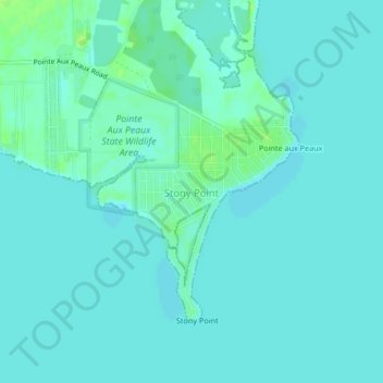
Name: Stony Point topographic map, elevation, terrain.
Location: Stony Point, Monroe County, Michigan, United States (41.93087 -83.29488 41.95215 -83.25314)
Average elevation: 568 ft
Minimum elevation: 558 ft
Maximum elevation: 594 ft
Monroe County trails, hiking, mountain biking, running and outdoor activities
Make a donation
Gear up for your next adventure:
As an Amazon Associate, this site earns from qualifying purchases at no extra cost to you.
Other topographic maps
Click on a map to view its topography, its elevation and its terrain.
Berlin Township
United States > Michigan > Monroe County > Berlin Township > Berlin Township
Average elevation: 581 ft