Geolocate

Nebo topographic map

Click on the map to display elevation.

About this map

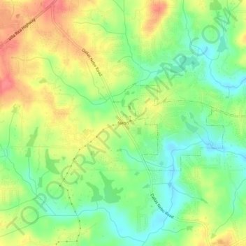
Name: Nebo topographic map, elevation, terrain.

Location: Nebo, Hiram, Paulding County, Georgia, 30140, United States (33.81844 -84.85161 33.85844 -84.81161)

Average elevation: 1,040 ft

Minimum elevation: 938 ft

Maximum elevation: 1,155 ft

Paulding County trails, hiking, mountain biking, running and outdoor activities

Gear up for your next adventure:

🧣Hiking Neck Gaiter - Multi‑use neck protection for outdoor weather
🩳Quick‑Dry Hiking Shorts - Comfortable and quick‑dry shorts for summer hiking
🗻Climbing Gear Basics - Essential gear for beginner climbers
📖Nature Tracking Books - Learn to track wildlife and terrain
🧯Emergency Survival Kit - All‑in‑one survival essentials for the backcountry

As an Amazon Associate, this site earns from qualifying purchases at no extra cost to you.