
Make a donation
Gear up for your next adventure:
As an Amazon Associate, this site earns from qualifying purchases at no extra cost to you.
East Montpelier topographic map
Click on the map to display elevation.
Make a donation
Gear up for your next adventure:
As an Amazon Associate, this site earns from qualifying purchases at no extra cost to you.
About this map
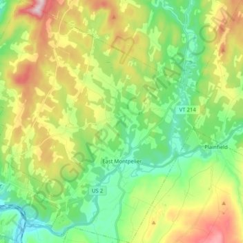
Name: East Montpelier topographic map, elevation, terrain.
Location: East Montpelier, Washington County, Vermont, United States (44.23386 -72.57395 44.34542 -72.42927)
Average elevation: 1,020 ft
Minimum elevation: 525 ft
Maximum elevation: 1,896 ft
Washington County trails, hiking, mountain biking, running and outdoor activities
Make a donation
Gear up for your next adventure:
As an Amazon Associate, this site earns from qualifying purchases at no extra cost to you.
Other topographic maps
Click on a map to view its topography, its elevation and its terrain.
Make a donation
Gear up for your next adventure:
As an Amazon Associate, this site earns from qualifying purchases at no extra cost to you.
North Montpelier
United States > Vermont > Washington County > East Montpelier
Average elevation: 912 ft