
Degersheim topographic map
Interactive map
Click on the map to display elevation.
About this map
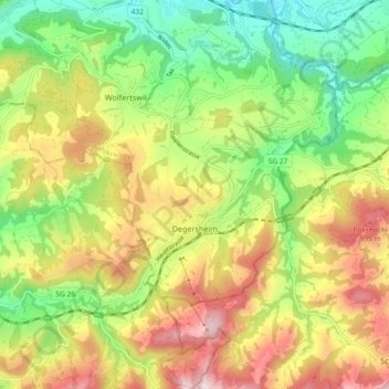
Name: Degersheim topographic map, elevation, terrain.
Location: Degersheim, Wahlkreis Wil, Saint-Gall, 9113, Suisse (47.34778 9.14225 47.41030 9.22200)
Average elevation: 2,618 ft
Minimum elevation: 1,919 ft
Maximum elevation: 3,501 ft
Other topographic maps
Click on a map to view its topography, its elevation and its terrain.
Uzwil
Suisse > Saint-Gall > Wahlkreis Wil
Uzwil, Wahlkreis Wil, Saint-Gall, Suisse
Average elevation: 1,873 ft
Flawil
Suisse > Saint-Gall > Wahlkreis Wil
Flawil, Wahlkreis Wil, Saint-Gall, Suisse
Average elevation: 2,277 ft