
Tlalnepantla topographic map
Interactive map
Click on the map to display elevation.
About this map
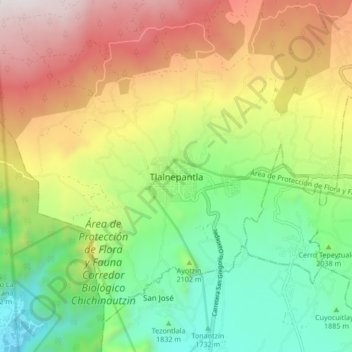
Name: Tlalnepantla topographic map, elevation, terrain.
Location: Tlalnepantla, Morelos, México (18.96850 -99.03712 19.04850 -98.95712)
Average elevation: 7,162 ft
Minimum elevation: 5,171 ft
Maximum elevation: 9,941 ft
Other topographic maps
Click on a map to view its topography, its elevation and its terrain.
Felipe Neri
México > Morelos > Tlalnepantla > Felipe Neri
Felipe Neri, Tlalnepantla, Morelos, México
Average elevation: 8,255 ft