Geolocate

Tala topographic map

Click on the map to display elevation.

About this map

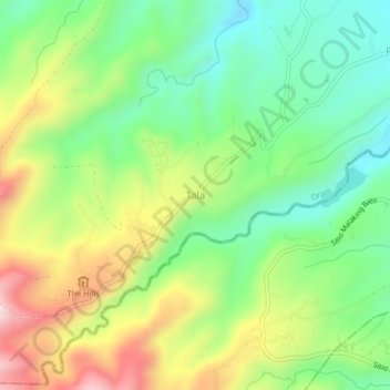
Name: Tala topographic map, elevation, terrain.

Location: Tala, Orani, Bataan, Central Luzon, Philippines (14.73428 120.41010 14.77428 120.45010)

Average elevation: 1,234 ft

Minimum elevation: 620 ft

Maximum elevation: 2,198 ft

Gear up for your next adventure:

🌎3D Topographic Globes - Raised relief globes for a tactile understanding of geography
📚Navigation Handbooks - Master the art of reading topographic maps and using a compass
🍳Camping Cook Set - Complete cookware for outdoor meals
🥘Titanium Cookware - Durable, featherlight pots and pans for backpacking
🏥Hiking First Aid Kits - Comprehensive medical kits for remote trail injuries

As an Amazon Associate, this site earns from qualifying purchases at no extra cost to you.