Geolocate

Venture topographic map

Click on the map to display elevation.

About this map

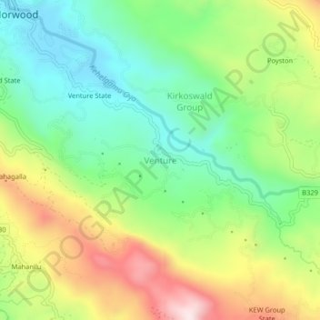
Name: Venture topographic map, elevation, terrain.

Location: Venture, Nuwara Eliya District, Central Province, Sri Lanka (6.80062 80.61042 6.84062 80.65042)

Average elevation: 4,301 ft

Minimum elevation: 3,635 ft

Maximum elevation: 5,348 ft

Other topographic maps

Click on a map to view its topography, its elevation and its terrain.

Matale District

Sri Lanka > Central Province

Average elevation: 886 ft

Upper Kotmale Dam

Sri Lanka > Central Province > Talawakele > Holyrood

Average elevation: 4,098 ft

Sigiriya

Sri Lanka > Central Province

Average elevation: 666 ft

Nuwara Eliya District

Sri Lanka > Central Province

Average elevation: 3,586 ft

Pitawala Pathana

Sri Lanka > Central Province

Average elevation: 2,421 ft

Canyon Dam

Sri Lanka > Central Province > Hapugastenne

Average elevation: 3,615 ft

Gear up for your next adventure:

🔋Rechargeable Batteries - Power up your outdoor devices
🏕️Family Camping Gear - Essentials for group camping trips
🥄Camping Utensil Set - Lightweight utensils for outdoor meals
🕶️Glacier Sunglasses - Side shields to protect eyes from high-altitude snow glare
Camping Coffee Makers - Enjoy premium coffee at the summit or campsite

As an Amazon Associate, this site earns from qualifying purchases at no extra cost to you.