
Make a donation
Gear up for your next adventure:
As an Amazon Associate, this site earns from qualifying purchases at no extra cost to you.
Utakura River topographic map
Click on the map to display elevation.
Make a donation
Gear up for your next adventure:
As an Amazon Associate, this site earns from qualifying purchases at no extra cost to you.
About this map
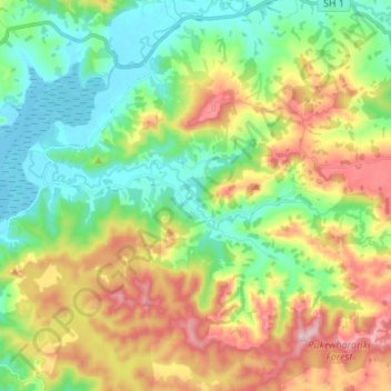
Name: Utakura River topographic map, elevation, terrain.
Average elevation: 407 ft
Minimum elevation: -3 ft
Maximum elevation: 1,106 ft
Make a donation
Gear up for your next adventure:
As an Amazon Associate, this site earns from qualifying purchases at no extra cost to you.
Other topographic maps
Click on a map to view its topography, its elevation and its terrain.
Waihou Valley
New Zealand > Northland > Far North District > Kaikohe-Hokianga Community
Average elevation: 282 ft
Pukawa
New Zealand > Northland > Far North District > Kaikohe-Hokianga Community
Average elevation: 331 ft
Broadwood
New Zealand > Northland > Far North District > Kaikohe-Hokianga Community
Average elevation: 472 ft
Whirinaki
New Zealand > Northland > Far North District > Kaikohe-Hokianga Community
Average elevation: 233 ft
Make a donation
Gear up for your next adventure:
As an Amazon Associate, this site earns from qualifying purchases at no extra cost to you.
Rangitoto
New Zealand > Northland > Far North District > Kaikohe-Hokianga Community
Average elevation: 79 ft
Fern Hill
New Zealand > Northland > Far North District > Kaikohe-Hokianga Community
Average elevation: 400 ft
Rotokakahi
New Zealand > Northland > Far North District > Kaikohe-Hokianga Community
Average elevation: 295 ft
Runaruna
New Zealand > Northland > Far North District > Kaikohe-Hokianga Community
Average elevation: 266 ft
Make a donation
Gear up for your next adventure:
As an Amazon Associate, this site earns from qualifying purchases at no extra cost to you.
Tauwhare
New Zealand > Northland > Far North District > Kaikohe-Hokianga Community
Average elevation: 922 ft